Moose!! Moose!!
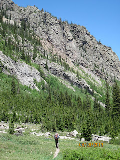
We also hiked past his camp, Camp Hale, the remains of which are seen here:
Apparently you can ski where he trained at Ski Cooper near Leadville, along a hut system that goes back to the Tenth Mountain Division as well.
This is Kokomo Pass, from which you have a lovely view of a huge mining operation...
Here we are up at Insterstate 70. Ironically, as we took the "alternative" route, we wound up going through two of the most beautiful wilderness areas we've traveled through -- Eagles Nest and Ptarmigan. Photo below: Jay doing his best to look goofy. Utah is getting her leash on but can't be seen here.
The following is a composed art photo taken by Kevin. It's called "Dog, Nose, Mountains."
The Climbing and Descending Trail (aka, the Character Development Trail).
Ptarmigan Peak Wilderness: This was a doozy of a hike, with a 2,000 foot elevation, descent, and elevation again... Kevin partially smiles here, simply because he has no idea of what he's about to get into. One great benefit was that we saw an entire herd of elk in one of the valleys we traveled through (unfortunately, the photo we took made them look like pixilated dots).
The REI photo op: UL3 Fly Creek by Big Agnes: 3 people 3 lbs (above). Below is our camp right before a rain storm in the Ptarmigan Peak Wilderness. This hike really explained the idea of a "language of light."
To explain the above photo: We decided to hike up to Rollins Pass on our way out of Winter Park. On the road two train aficionados let us ride up to the pass in the back of their pick up. The ride was, how you say?, "bumpy." We stopped at this old train trestle. The Old West's remains...
With the ride up we got to the top much sooner. We camped near the pass at a beautiful lake. While Jay and I took a trail zero, Kevin slack-packed back to Rogers pass. It was a wild afternoon with tremendous thunderstorms mixed with fantastic light and shadows. Jay and I saw a rainbow down in the valley from over the top. We were "over the rainbow": Hello, Dorothy and Toto. Kevin had to call out to us when he got back in the early evening because we were completely socked in by fog.
Understand: The clouds shown below will congeal into thunderstorms with huge hail later in the afternoon.
Contemplative dog:
This is coming into the area of Grand Lake.
Ley cryptically says to look for a Tardis here? Looks more like a Dalek to me. EXTERMINATE...EXTERMINATE Our best guess: it is an old steam powered winch.
Lake country, we got to Little Moose Trading Company in time for Muffins and Brownies. Then deciding to skip Knight Ridge and get to Grand Lake on July 3rd, we hitched from the trading Post to the Grand Lake Post Office. We got a hitch in the back of another pick up, got our boxes, and then headed up to the Shadow Cliff hostel. We had a great time meeting people there, but boy it is a haul up to the top of the cliff. Worth it though. It may be the coolest hostel we've seen. It reminded Jay of the Weasleys' house in Harry Potter.
In this photo, Kevin is wondering: "Will that thing hold up under that weight?" To explain: We had the worst Fourth of July ever. A new friend from the hostel gave us a ride to the Ley trailhead that skips Rocky Mountain National Park (some of which was on fire and thus closed). This is where we wound up. ATV hell. We got turned around on the road, because it was signed poorly (translation: never signed) and finally made it to the actual trail by around 7 PM. Exhausting.
Moose on the ATV trail. "I need me one of dem four wheeler thangs and a couple of beers."
The end of ATV hell was a beautiful ridge hike (ah, yes, just what the CDT should be). Towards the end of the ridge hike, we met a few hikers who took this photo of us about to enter the Never Summer Wilderness. On the trail again!
Awesome ridge hike, just as hail and rain and clouds and lightning and more clouds move in -- a typical day on the latter part of our Colorado chunk hike.
The Columbine just started blooming in the higher elevations.
The climb to Parkview. There is new trail here (if you look close in this photo, you can see Mama Moab and Captain Underpants, as well as a huge cairn). Many people using Ley were mapless for this new trail. I had a track from either Ley or Starman that was called 2013 CDNST Beta in my gps that did have the new track, so we used that. The new trail follows the South side of the mountain then climbs to a saddle, then climbs and climbs and climbs. The summit was fantastic on the first hailless afternoon in a week. We could see into Wyoming and back a long way.
Top of Parkview Mountain, where there is an old fire lookout (not really Old but not quite New West). Kevin sat down and wrote a novel in one sitting on top of the mountain, called, "On the Road." In the photo below, you can see Utah eating the manuscript, which is right next to Kevin's pack.
We then descended (we had no choice) and found some snow melt water in the saddle after our descent and camped at 11, 000 feet probably for the last time of this hike. It's all down hill from here.
My knee brace has held up pretty well but I keep hearing Pikas but not seeing them? squeak, squeak. Kevin wanted to rename my trail name to Squeaky, but we both agreed that that had bad connotations. Below is another contemplative dog photos, one of many in a long series...
The wild flowers have really come out in July. We are seeing high meadows full of flowers, some are old friends like Colorado Columbine and Indian Paint brush. Others are new to me like these tiny blue forget me not looking flowers we only see above 11,000 ft. The flowers are small only 2 mm across.
As we got closer to our conclusion at Rabbit Ears Pass, the mountains got lower and had these fantastic rock formations. On the morning we were headed out to highway 14 we had a parade of hikers go by our camp. First I saw Joe, then Bo (we wondered if we'd see Mo)... We shared coffee with Bo and expected to see him in Wyoming. Later we saw Raisins. The day before, we camped under Mount Hyannis (Buck Mulligan, in typical style, kept calling it Mount High-Anus) with Sunday. We cooked him a fusion meal of mashed potatoes and Pad Thai. We put Iron Chef to waste.
On July 9th we made it into Steamboat Springs by about 2 PM, rented a car and drove all the way back to South Fork in about 5 hours, providing us a sense of humility. We traveled our trail in reverse going through Silverthorne, Copper Mountain, Leadville and Buena Vista. We got to South Fork, stayed in our usual cabin at Good Night Lonesome Dove. It was shocking how 5 weeks of hiking can take so little time in the car, about an hour a week. It was a relief that those we knew in South Fork were safe after their forests had been burning for so long.
In the morning Kissable Captain Underpants (KCU) was delighted to pitch his heavy old North Face pack in the dumpster. After 3000 miles, it was done and out grown. Jay is now taller than me by several inches. He goes off to build trail, while Kevin and I go to Wyoming to chunk hike that state.... More later.


I love seeing your adventures! Also it was great to hear a story about your dad/my granddad (I did not know he was the only survivor!). Caspian is becoming a great hiker and I hope that we can join you sometime on one of your trips out west. Also, just FYI we are just about to get certified as foster/adopt parents!
ReplyDeleteGreat photos and good weather; you must be livin' right. Continued safe passage - enjoy every moment and step you take. Be safe and take more photos. Cheers to your dad and the 10th Mountain Div.
ReplyDelete